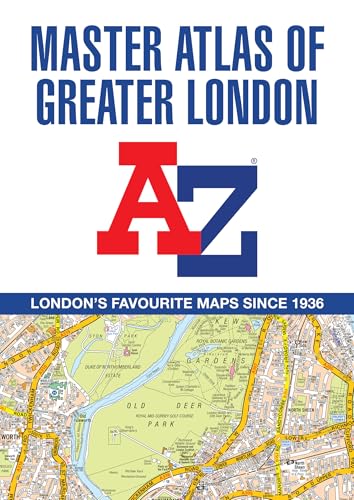
A -Z Master Atlas of Greater London
Detailed and Accurate Iconic Street Map of London
(Autor) A-Z MapsThe ultimate street atlas to navigate your way around London. This comprehensive, paperback atlas encompasses an area of 1,450 square miles, including more than 90,000 streets and other addresses, and is trusted by local authorities, taxi drivers and emergency services. The coverage extends beyond the Greater London and M25 area to: Hemel Hempstead, St. Albans, Potters Bar, Waltham Cross, Epping, Brentwood, Thurrock, Stanford-le-Hope, Gravesend, Wrotham, Sevenoaks, Westerham, Oxted, Redhill, Reigate, Leatherhead, Great Bookham, Woking, Egham, Windsor, Slough, Chalfont St. Peter, Chorleywood, Bovingdon There are eighteen pages of large scale (9" to 1 mile) street mapping of central London which gives additional clarity and detail, this mapping extends to: Regent's Park, St. Pancras International Station, Old Street, Tower Bridge, Bricklayer's Arms Junction, Vauxhall Bridge, South Kensington, Paddington Station and Lord's Cricket Ground. Postcode districts and one-way streets are included on the street mapping. Other features include: The Congestion Charging Zone (CCZ) boundary which is shown on both scales of mapping and an overview map of the zone is also included The Greater London Low Emission Zone boundary is shown on the street mapping and an overview map of the zone is also included The Ultra Low Emission Zone (ULEZ) boundary There are eight pages of road mapping at 3 miles to 1 inch that cover much of the Home Counties area London Underground map London Rail Connections map West End Cinema and Theatre maps The index section of the atlas includes streets, places & areas, hospitals, industrial estates, selected flats & walkways, service areas, stations and selected places of interest. Please note hospitals and rail stations are now listed in the main index and highlighted in different colour. They are not included as a separate list as in previous editions.
A-Z Maps
A-Z Maps is a renowned cartography company known for their detailed and accurate maps. Their most famous work includes the A-Z London Street Atlas, a staple for navigating the city. Their clear and user-friendly style has revolutionized the way people explore and understand urban landscapes.
Other related

Great Britain A-Z Handy Road Atlas 2026 (A5 Spiral)
Easy to Read Map of Great Britain in A5 Size with Spiral Binding
Great Britain A-Z Super Scale Road Atlas 2026 (A3 Spiral)
Easy to Read Map of Great Britain in A3 Size with Spiral Binding